
Ke Wang
ADAPTIVE REUSE OF GOVAN GRAVING DOCKS HOUSING-LED REGENERATION
Industrial Heritage, Flood Risk and Mixed-tenure Housing
How can adaptive reuse and flood-resilient design enable housing-led regeneration on an industrial heritage site in Govan?
My project explores how adaptive reuse and flood-resilient design can support housing-led regeneration at Govan Graving Docks.
The site has three connected challenges. It contains important industrial heritage, it is exposed to tidal and surface-water flood risk, and it is physically disconnected from Govan, while Glasgow continues to need more affordable housing.
So, instead of treating heritage, flooding and housing as separate problems, my proposal combines them within one urban framework.
The strategy can be summarised in four actions: protect, adapt, add and connect.I protect the three historic docks and important industrial structures. I adapt them as public spaces, heritage assets and community destinations. I add mixed-tenure housing on protected development land.
Finally, I reconnect the site to Govan through continuous pedestrian routes and a public waterfront promenade.The dock geometry is not treated as an obstacle. It becomes the structure that organises the new streets, blocks and open spaces.
Inhabiting the Govan Graving Docks Housing-led adaptive reuse of industrial heritage under flood risk
Inhabiting the Govan Graving Docks :Housing-led adaptive reuse of industrial heritage under flood risk
Govan dry docks, located along the Glasgow Clyde River, is an A-class registered industrial heritage consisting of three 19th-century dry docks, granite dock walls, work surfaces, pump rooms and related paths. Its value lies not only in the single structure, but also in the overall relationship between the dock, river, terrain, labour memory and the Gowan community that is still clear and readable. Only pursuing the renewal of the number of housing, tourism image or a single flood control project may weaken this relationship.
This study explores: How can the housing-led adaptive reuse framework make mixed property communities live in the industrial landscape of Govan dry docks while maintaining flood control safety, public traffic and heritage readability? “Living” is not simply adding residences next to the heritage, but a mutually beneficial spatial and institutional relationship: housing brings long-term use, maintenance of resources and daily public life; heritage continues to organise streets, sight, architectural scale and community identity; flood control facilities have both safety infrastructure and public space functions.
The research adopts the site-specific “design-based research” method to identify the materials and relationships that need to be retained through historical maps, registration files and spatial analysis, and establish a preliminary risk model in combination with housing, planning, heritage policies, official flood information, GIS overlay and east-west profiles. The Royal Albert Pier, Hamburg Harbour City and the Niederhafen Waterfront Trail are used as comparison cases to extract the translatable principle, not the direct copy form.
The final plan consists of four operations: “protection, adaptation, increase and connection“: “protection” takes three docks and their linear operation order as the spatial skeleton; “adapts” to establish elevated safety routes, protected housing land and controlled low-rise public spaces; “increase” through courtyard blocks and revitalise the first floor , mixed property rights housing and community facilities are introduced for long-term residence; “Connection” uses continuous riverbank paths and east-west passages to reconnect Gowan Road, existing communities, the edge of the dock and the Clyde River.
About 45,600 cubic metres of dock flood storage, about 1,500 residential units and 30%/20%/10%/40% property rights combinations are design test assumptions, not verified implementation indicators. The project still needs to carry out special flood risk assessment, structural and geotechnical survey, pollution and water quality research, residential details, development feasibility assessment and community participation. The study believes that only when heritage protection, housing equity, public access and climate adaptation are jointly designed, managed and maintained for a long time can housing-led renewal constitute credible adaptive reuse.
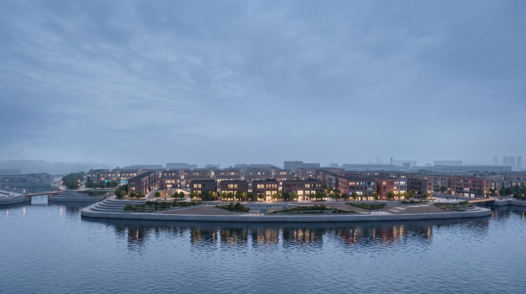
The riverfront proposal combines mixed-tenure housing with a continuous public promenade and layered flood-resilient landscape along the Clyde.
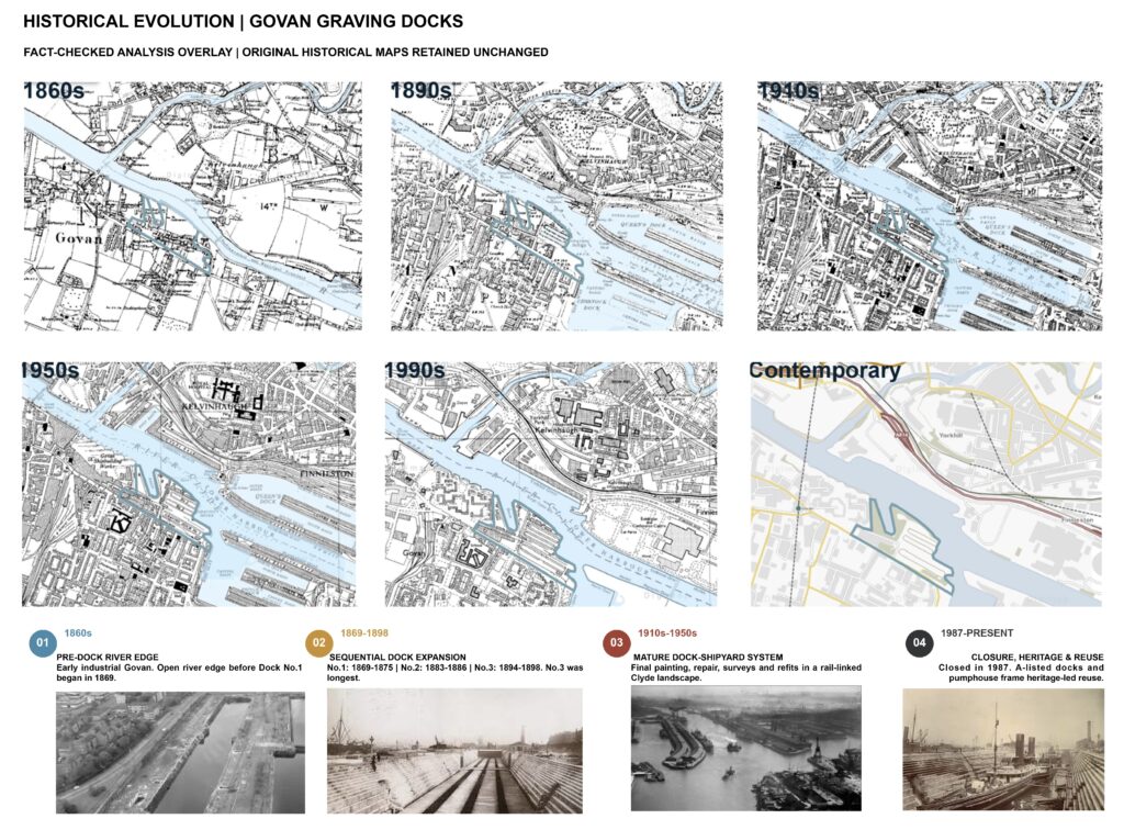
Comparative historical maps and archival images show the docks’ development from the pre-dock river edge through industrial expansion, closure and heritage-led reuse.
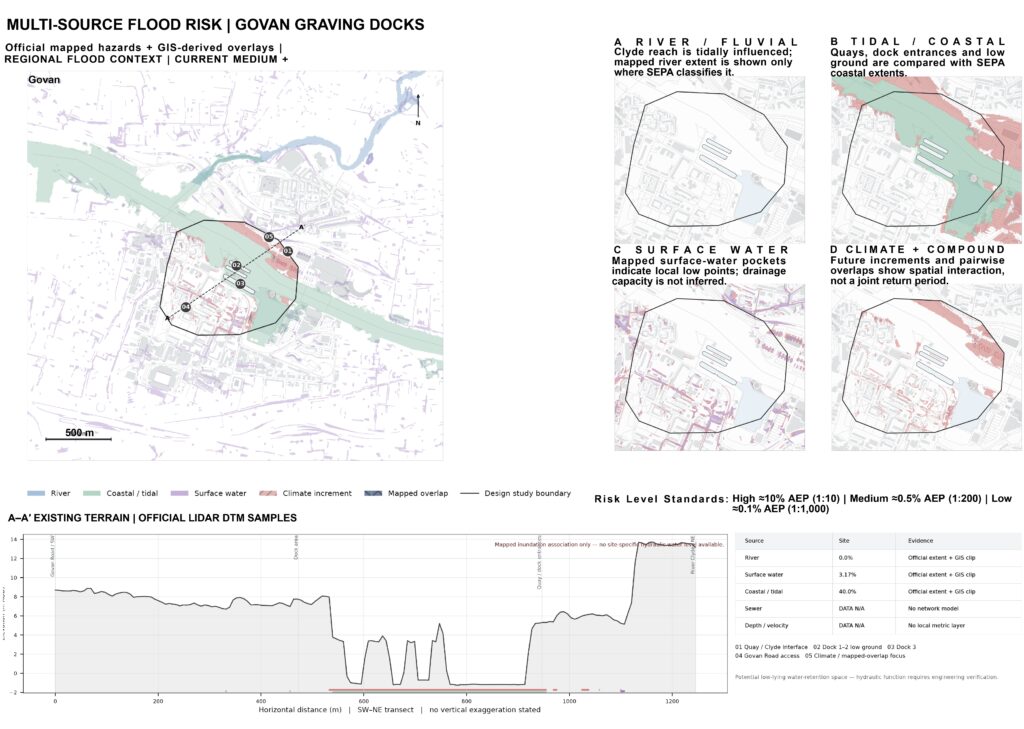
Official mapped hazards and GIS-derived overlays compare river, tidal and coastal, surface-water and climate-related flood exposure across the Govan Graving Docks site.
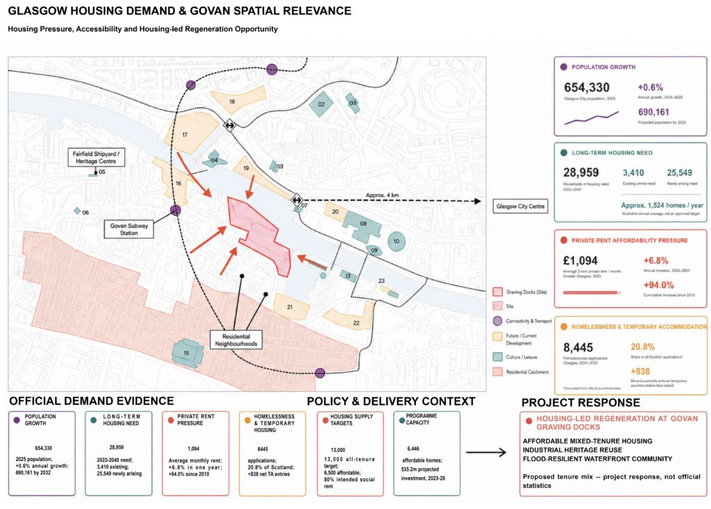
Housing-demand evidence and spatial analysis connect Govan Graving Docks with surrounding neighbourhoods, public transport, cultural facilities and Glasgow city centre.
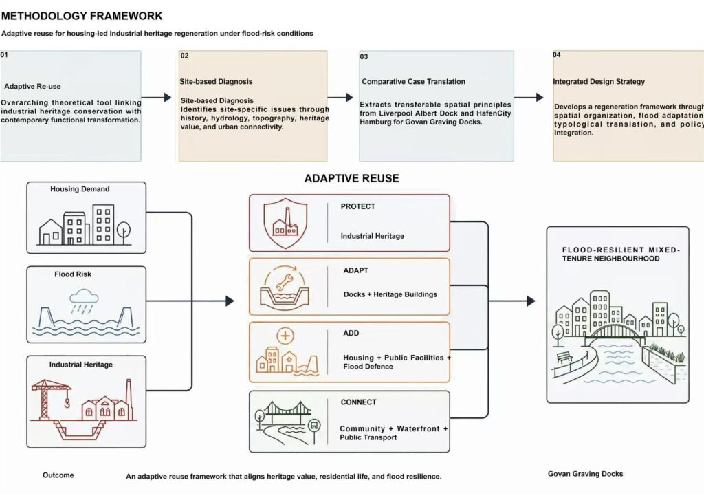
The methodology combines site diagnosis, comparative case translation and integrated design through four actions: protect, adapt, add and connect.
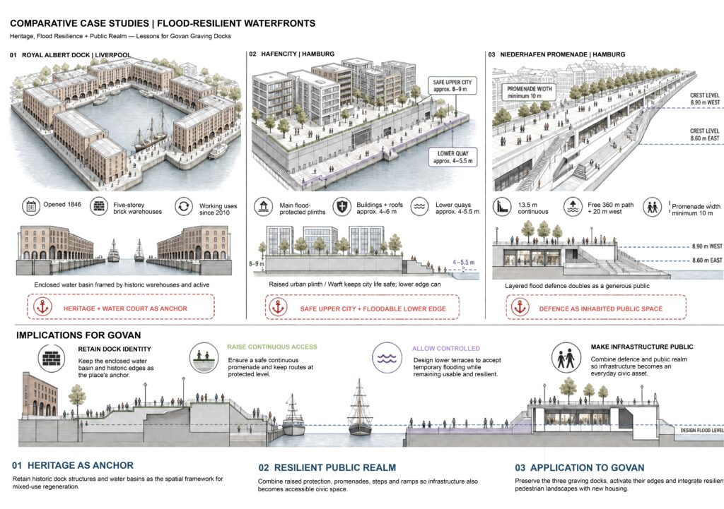
Royal Albert Dock, HafenCity and Niederhafen Promenade provide transferable principles for combining industrial heritage, flood resilience and accessible waterfront public space.
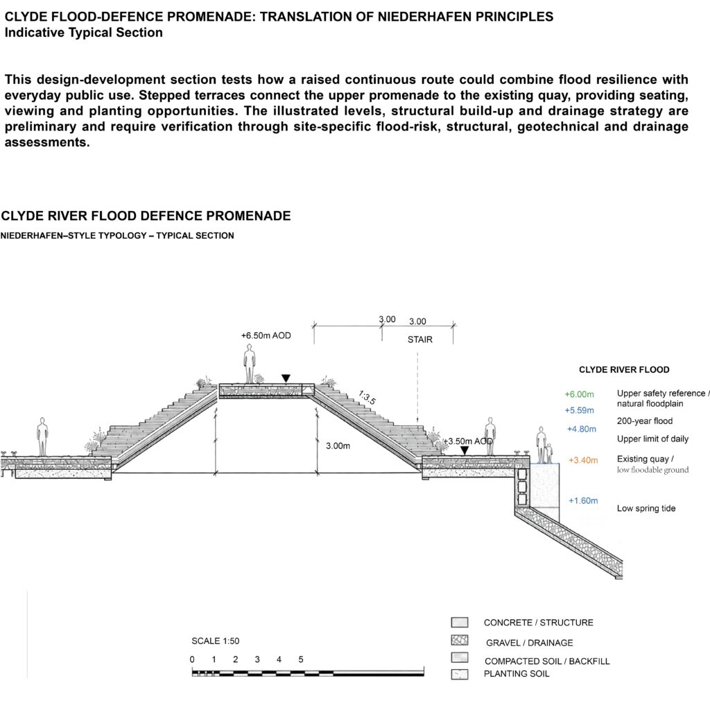
A Niederhafen-inspired promenade combines a continuous raised flood-protection route with stairs, seating, planting and access to the lower Clyde quayside.
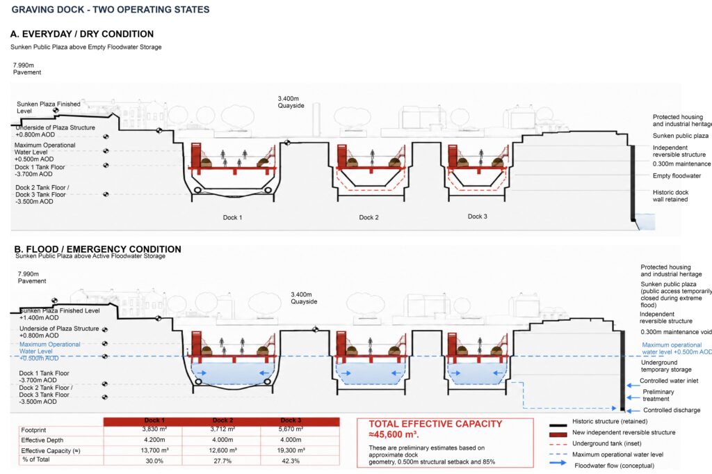
Everyday and emergency sections illustrate how reversible public platforms could retain the historic dock walls while allowing temporary floodwater storage below.
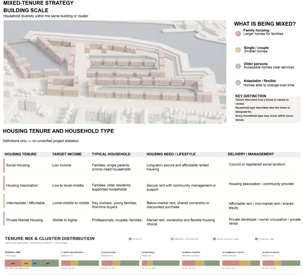
The building-scale strategy mixes different household types and housing tenures within each cluster to support a socially diverse waterfront neighbourhood.
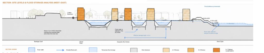
The west-east section coordinates protected housing levels, temporary storage within the historic docks and a raised riverside promenade forming part of the flood-resilience strategy.
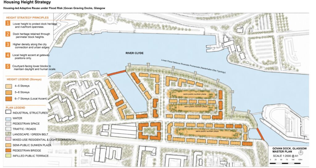
The masterplan uses lower waterfront buildings, moderate perimeter blocks and limited gateway accents to balance housing density with dock visibility and riverfront openness. Description
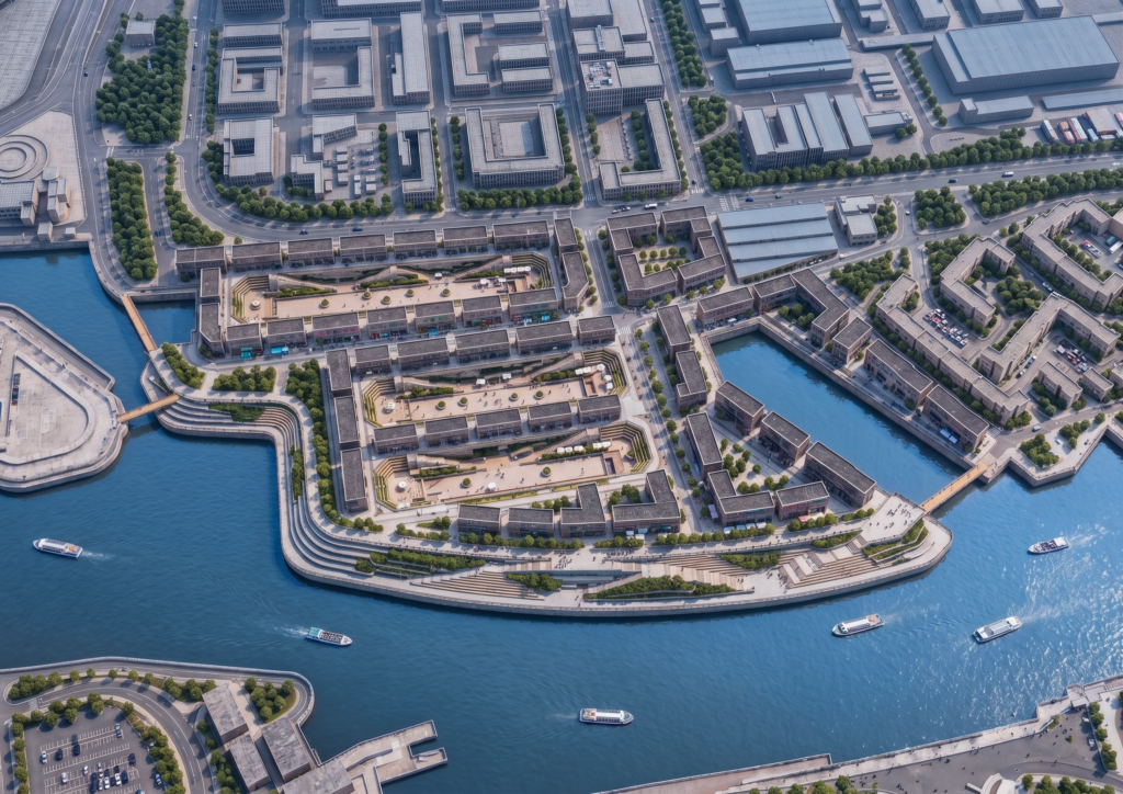
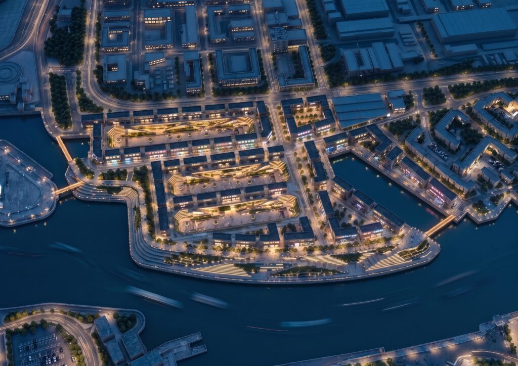
The night-time view shows the three docks as illuminated civic spaces within a connected mixed-tenure waterfront neighbourhood.
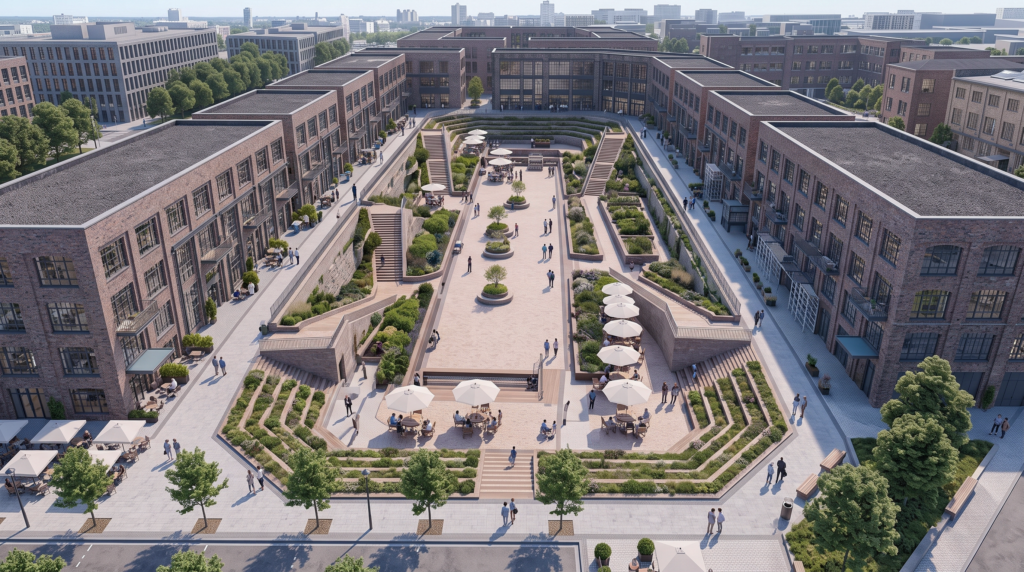
The retained dock geometry is transformed into an active public landscape with gardens, seating, cafés and pedestrian routes framed by new housing.