Sushrut Shankar (He/ Him)

The project is an anecdote exploration of Glasgow’s own river Clyde can be transformed into a flood-resilient place where people can enjoy different types of activities on the edge of the river while adding the ‘ Place-ness ‘ it has lacked for a very long time. The idea revolves around how macro and micro-urban scale interventions with a simple section running along the river can completely upgrade the river for tackling current issues as well as future flooding.
Works
Habitable Clyde Edge
“This project is an anecdotal effort to explore the possibility of retrofitting a river edge
with flood resilience design interventions. Tried on the banks of the river Clyde of Glasgow’s city center,
how this newly imagined riverfront can tackle not only future flood issues but also bring the
City together on its bank to rekindle the experience of a river as an ‘intimate’ part of the
city.”Bringing people closer to the water by adding “rooms” and creating active ” frontages” on the streets.
Site Analysis
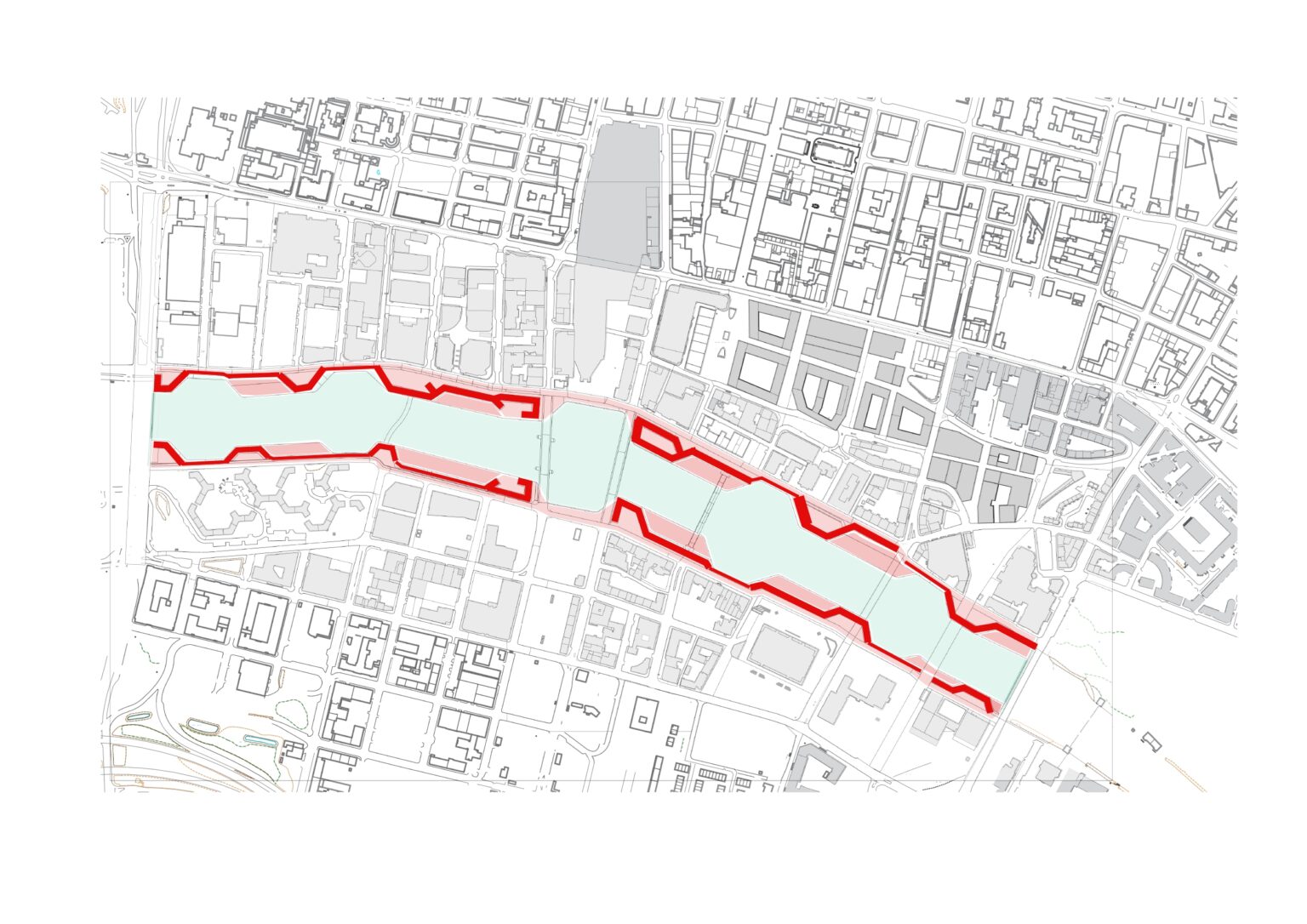
The existing conditions of the river Clyde are quite disappointing when it comes to the question of accessibility along the south bank of Clyde. As seen in the map there is no connection to the southeast bank for pedestrians and no visible connection from Ingram Street to the south. With the presence of a lot of empty plots on the east and northwest banks, there are very few places that animate activities on the Clyde Bank. The discontinuity in the urban fabric is very well visible in the form of the grid pattern break and the enormous height difference between the buildings on Custom Quay and Carlton Place which additionally makes the river edge visually distinct and diminishes the experience of it when traversing from north to south. The north bank has limited crossings for people to cross the road to reach the bank with railings running along the center of the 4-lane road near the IFSC center. The blank canvas of the edge not only fails to stimulate activities it restricts the users to mostly people strolling or jogging along the Clyde with very less mixed-aged users. As opposed to the amount of area the edge already has and the potential to change these challenges into solutions we take a look at the historical context of “what river Clyde once was as it might hold the answer for what it might become”
Historical Analysis
As Glasgow has always been in the SHIPBUILDING industry we see through these images that the bank earlier was used to have these ‘shed-like structures which were used for goods storage and were accessible through both sides. These ran parallel to the river and had widths ranging from 10m wide to 25 m. We can also see that the proportions of the buildings around Clyde were of human scale ( ranging from ground to + 3 floors ) which added to the picturesque town in age. This forms the base for what is being proposed as a habitable wall infrastructure ahead.
Urban Form Evolution
Step 1 – Create
This method helps in providing more land area for the edge and hence if done strategically, it will provide opportunity for infrastructure. An example of this being used is the artificial palm islands of Dubai. In Glasgow’s context, we observe the width of the river keeps changing from 80m @ Glasgow green to 135 m at the customs quay. Channeling it to a constant of 80m will help acquire more land and a way to make it flood-resilient. To make the water tides more stable we shifted the weir from Glasgow Green to just west of Kingston Bridge hence the water level rising to the edge of the fabric.
Step 2 – Alleviate ( Pools )
This method is used to allow water into the city or to ‘make room for water’. This is one of the best-recognized methods for flood adaptability as the public spaces on the edge allow the temporary expansion of the river by allowing it to flood them. A small element of this is the water squares in Rotterdam and the morocco plaza of Ha-fen city. To introduce this, a decision was made to add circular reservoirs which let the water flow in an outwards direction towards the city and help the circulation of water in a loop as it slows down the speed. These reservoirs were placed in such a way that the total area of the newly formed edge above is equal to the area of the old/ existing Clyde Bank and creates an interplay of water in these “pools” to come nearer to the city.
Step 3 – Alleviate ( Rooms)
Continuing the pool intervention, the next step was to create flood-able spaces of the future which will be used currently and be part of the place-making goal of this project. Hence the creation of ‘rooms’ which sit ‘3.5 m to 4 m below the upper edge and provide an opportunity for the public to approach the river more physically and visually. A similar example of this can be seen in the ‘Chicago River Walk’ where different rooms open up to the river with different activities for the public to engage in. Each of these rooms has a unique identity responding to the context of “2 urban blocks” of the river. For example, the ‘cafe room ‘ (the room with all the cafes and restaurants) sits right outside of the IFSC district as it will receive people at different times of the day and night.
Step 4 – Restrict
This method of building a fence or a wall along the river is the most known and followed across the world. Though this is not considered the safest means of flood adaptability, it restricts the water well enough for years with a slight risk of everything failing once the wall is breached. It is also called dykes in Denmark where it had been used traditionally. Though this last step of making a wall for ‘restrict’ gives the idea of a plane single wall running straight along the river’s edge, here the interplay of the wall being part of an ‘urban infrastructure’ takes place. The wall takes its width and placements from the historic ‘sheds’ Glasgow used to have in the early 20th century for storage of goods. This in turn provides courts on the upper edge for more engaging activities and a raised walkway sitting 3.5m above the street level for unbridled views of the river and the skyline.
Pre flooding and Post flooding conditions
The flooding conditions here as depicted as pre and post-flood where the rooms that are used for activities embracing the river, get flooded in the future and offered back to the river for it to expand on and flow.